Hibsch's nature trail (Křížová hora, Dlouhý vrch) - Žitenice
Explore the geology of the Bohemian Central Highlands and enjoy a visit to the Hibsch Cave and the view from Křížová hora.
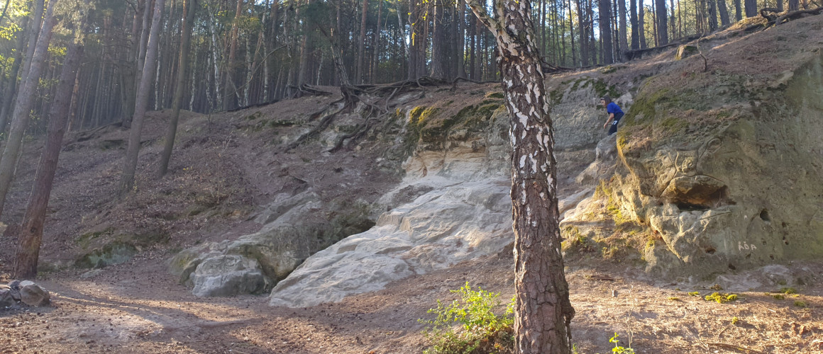
The circular trail with 13 stops was named after Josef Emanuel Hibsch, a world-renowned geologist. On the trail you will find 12 quartzite boulders, each named after an important scientist.
Route - length, start and finish
- The nature trail itself is 3.5 km long, with a trip over Křížová hora and Dlouhý vrch it is 10 km.
- The most popular stop is Hibschova cave, where you can start the trail. The trail after all stops is about 3.5 km long.
- From the eighth stop, you can continue along the blue tourist trail and climb to Křížová hora and Laffit's lookout, from where you can enjoy a beautiful view of Litoměřice and Podřipsko. The route is 6.5 km long in this form. From here you can continue to Dlouhý vrch along the Žitenická Trail through the Land of Castles and return to Skalice along the yellow trail. This circuit is just over 10 km long.
History
The Hibsch Trail was created in 1927 at the instigation of local history workers from Litoměřice and was focused on geological attractions in the vicinity of Žitenice, especially the large quartzite rocks between Skalica and the foot of Křížová hora. It is named after the geologist Josef Emanuel Hibsch, a native of Homola, who contributed most to the geological knowledge of the Bohemian Central Highlands. The individual quartzite blocks were then named after deserving naturalists and local history workers.
Stops
Dlouhý vrch (Long Hill)
Dlouhý vrch is located in the Bohemian Central Highlands about 5 km north of Litoměřice.
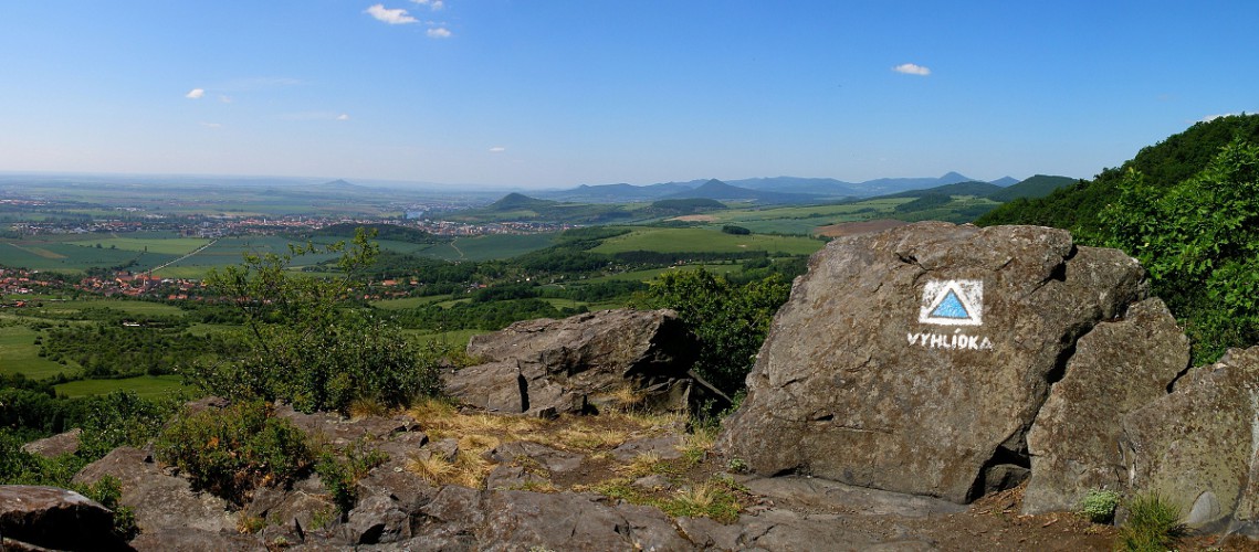
One of the largest rock massifs in the Czech Central Highlands, consisting mainly of tephrites - peaks and tephrite tuffs - slopes, located about 5 km from Litoměřice. The wooded hill is about 5.5 km long and stretches from north to south, about halfway up, its initially narrow part forks to the southeast and southwest, the span of this extension reaching about the same length as the main ridge. Apparently due to its considerable ruggedness it has been divided into several separately named sub-units, north-south followed by Vrchovina (676 m) with the attached Špičák (608 m) and Babinský or Rýdečský vrch (551 m), the eponymous Dlouhý vrch (655 m) and the Panenský kamen (607 m) group. The southernmost, rather south-southeastern outcrop is Křížová hora (590 m), with a protruding, visible from afar rock outcrop called Krkavčí, or also Kavčí vrch (500 m). This rock formation, about 30 m high, whose edges are characterised by a typical columnar detachment, has several viewpoints on its summit, including a marked main viewpoint, directed to the south-west, with views from Mělník across the Polabí and Elbe rivers to the nearby Owl Hill or Kočičí Castle - Kočka, Mostka, Litoměřice, Radobýl, Bídnice, Lovoš and the panorama of the more distant hills from Košt'álov to Milešovka and Kletečná, partly obscured by the nearby Plešivec and Hradiště, which close the view. In the past, the rock served as a training wall for climbers from Litoměřice.
The whole vast hill is interwoven with many forest paths and gravel roads, which lead to three hiking trails, the yellow trail between Staňkovice and Skalica Poustevna crosses the blue trail leading from Lbín via Křížová hora to Pohořany at the highest point of Dlouhé vrch. From the crossroads Tašov Ovčárna, a marked cycle path runs along the foot of the mountain, which then crosses the yellow marker and under the Panenský kamen it reaches the road near Myštice.
Certainly the nicest parts of this interesting hill can be seen on the way along the yellow sign from Staňkovice, massive boulder-like rubble with amazing, age-old specimens of beech trees, among which meander a few thin little streams - the beginnings of the Chudoslavický brook, a little higher on the sides of the wide forest road rise several tower-like rock formations. Continuing up Křížová hora, fresh and older, constantly changing passes open up nice partial views, west to Varhošt' and Radobýl, east to the Třebušín basin with Kalich, Trojhora and the more distant Sedlo. From the blue sign towards Lbín, Homolka and Varhošt' it is also possible to see some of the more distant hills, Radobýl, Hradiště, the top of Lovoš and Házmburk in the background.
The most open view, of Milešovka and the adjacent part of the Central Highlands with Varhoštěm in the foreground, can be seen from Vrchovina, but there is no marked trail leading to it; it is necessary to use the forest path and orient yourself according to the map. Fans of history, albeit recent, will see many remains of various ruined buildings along this route in the former military zone. From the slowly overgrown hillside there is a partial view of the northeastern panorama of hills with Kukla and Babinský vrch in the foreground.
In addition to the above-mentioned Chudoslavický brook, some other streams spring on Dlouhé vrch, Pokratický brook on the western slope of Dlouhé vrch, Močidelský brook on the southern slope of Panenský kamen and Trojhorský brook below Babinský vrch.